Son Catlar
- Carlos Vermeersch
- Feb 5, 2018
- 6 min read
Updated: Apr 14
Ancient name
Lacese
Chronology
Talaiotic Ia (1400–1150 BC) — Middle Ages
Dimensions
Area: 37.500 m²
Son Catlar is a large Talaiotic settlement located on a small elevation in the western part of Minorca—the most important settlement of the island's western section. It has its origins in the Bronze Age and reaches its maximum expansion, probably shortly before the Roman conquest of Minorca, in the 3ʳᵈ–2ⁿᵈ century BC. Its main feature is the imposing wall that surrounds it, the best-preserved in the Balearic Islands, with a layout of 864 meters. It was built around the 10ᵗʰ century BC (Talaiotic II) to the 6ᵗʰ century BC but was reinforced again in the 3ʳᵈ century BC with a series of rectangular towers (at least six), the latest defensive technical innovations of the ancient Mediterranean.
It possesses many buildings in its interior and exterior. The remains of at least four talaiots have been found included in the wall, as well as a possible navetiform, numerous houses and, outside the town's walls, two pre-Talaiotic hypogaea—artificial caves usually with funerary purposes. Occupying a central position is the sanctuary with the taula, now with the top half of the support stone missing and with only a few fragments remaining of the capstone. In the northeast sector, next to the wall, four talaiots are located, possibly related to the village's defensive system. Also in that area, facing north, is one of the two discovered gates, the second one being discovered only recently. To date, only the sanctuary and a small part of the wall have been excavated, although these are old excavations with few known details. Undoubtedly, the urban center continued to be used until the last moments of the Roman Empire.
The taula

Chronology
Talaiotic III (800–450 BC) — Roman period
Dimensions
Support stone
Height (current): 3.52 m
Width: 2.40–2.50 m
Depth: 0.50–0.57 m
Capstone
Depth: 0.65 m
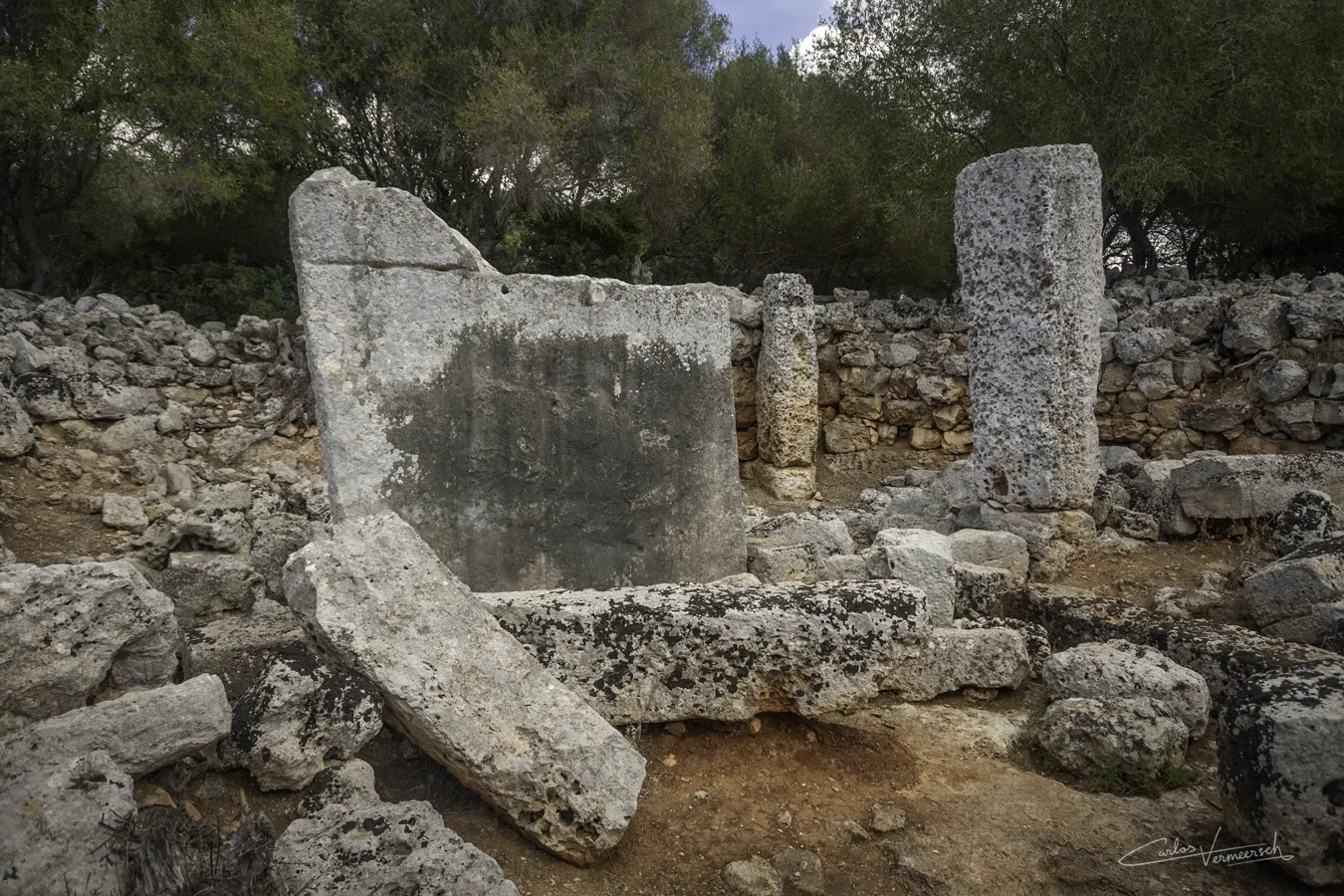
The sanctuary is strategically located in the very heart of the settlement. Its architectural design is particularly noteworthy, featuring a façade that boasts two entrances instead of the more traditional single entryway typically found in similar structures. This unique design choice may have been intended to accommodate a larger number of worshippers. The sanctuary houses a large taula. Unfortunately, this taula has suffered a tragic fate, as it was deliberately destroyed. The support stone of the taula has been cut in half, with the upper portion now missing. This act of destruction is evidenced by a distinct horizontal groove that has been carved into the support stone, clearly indicating that it was intentionally severed, rather than having succumbed to the ravages of time or natural disasters. Of the taula's capstone, which once adorned the top of the pillar, only a few fragments remain. To the right of the taula, there is a monolithic freestanding pillar, connected to the taula by means of a buried flagstone that reaches one of the two lateral stones that reinforce the taula. The precinct features a rectangular layout, with a slightly apsidal head and a concave facade. It has two entrance doors positioned on either side of a solid, square structure at the center of the facade. Inside, the decoration includes the usual pilasters, which rest on a baseboard. Opposite the "taula," there is a potential cistern, covered by a piece of semicircular stone.
One of the most important archaeological artifacts that have been recovered in the settlement is Iberian pottery. However, undoubtedly the most significant finding is two inscriptions bearing the legends LACESE (CIB 166) and LACESEN (CIB 167). LACESE appears on a prismatic stone, possibly a component of a door, found in 1924 in the taula sanctuary. LACESEN, possibly an abbreviation of the genitive form or perhaps its gentilicial, was found on another in the vicinity of the current walled enclosure, which only encloses part of the ancient settlement, which extended primarily toward the east, with other extensions to the south and north, where the necropoleis and quarries were located. These inscribed prismatic stones have also been interpreted as boundary markers of the territory of Roman Iamo and a community of indigenous origin called Lacese, at an early moment of Romanization.
The name Lacese can easily be etymologically linked to that of an Iberian people like the Lacetani, settled in the area of the current Catalan region of Solsonès and likely along the course of the Llobregat River, which was used to transport, among other things, minerals from the Pyrenees and salt from the mountain of Udula near Cardona. It is very easy to find a parallel Iberian toponym like Cesse (or Kesse), corresponding to the indigenous oppidum near which the Roman Tarraco was organized, a toponym widely known and corroborated through coins with Iberian inscriptions, but also from classical sources, like Titus Livius (59 BC–17 AD), who, when Latinizing it, refers to it as Cissis. It has been theorized that perhaps the two inscriptions could be interpreted as an abbreviation of LACESENSIS, with the Latin suffix -ēnsis to denote the genitive case, which does not negate a possible Iberian origin of the word which was Latinized (not surprising given that both inscriptions appear in Latin characters). On the other hand, the ending in -SEN could be the genitive case in Iberian, though the genetive used in Iberian coins from the Catalan area usually ends in -SKEN (untikesken, laiesken, auśesken, etc.). Either interpretation would render a similar meaning: "of those from Lacese", or perhaps, "from Lacese". Among other Iberian toponyms ending in -se are Arse, the Edetan settlement that gave rise to Sagunto, and Kelse, the Roman Celse, located near Velilla de Ebro in Zaragoza. Coins from both these towns, as well as from Cesse, have appeared in Minorca, curiously, especially from the latter.
The walls


Chronology
10ᵗʰ century BC (Talaiotic II) — 6ᵗʰ century BC (walls and gates)
3ʳᵈ century BC (towers)
Dimensions
Length: 864 m

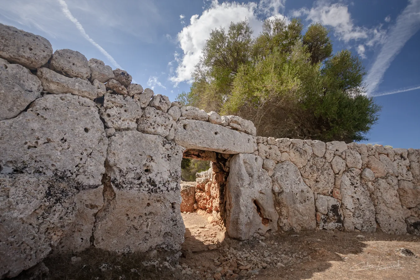
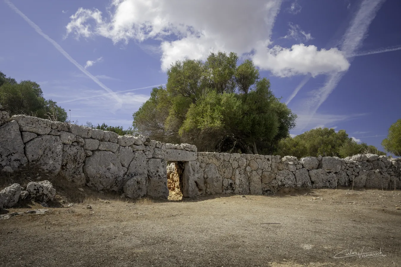
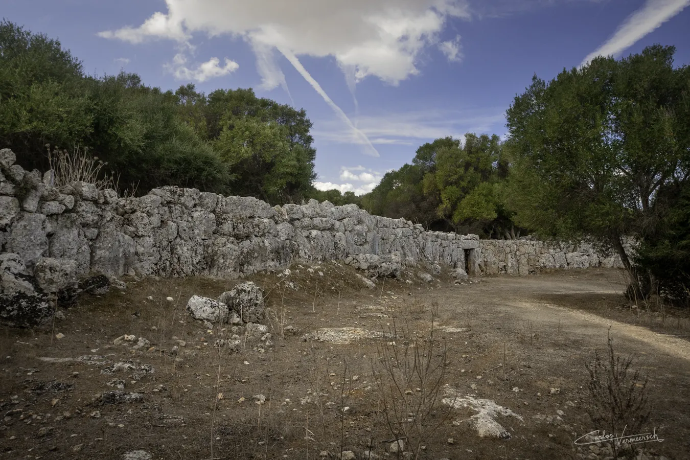
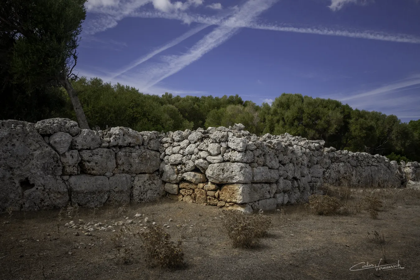
The most striking feature of this settlement is its well-preserved impressive walls. Towers, bastions, gates and casemates are easily seen in the wall. Several building techniques can be distinguished, belonging to different eras and later alterations. The oldest segments of the rampart, of the Talaiotic period, were constructed with a stone baseboard on top of which massive vertical unhewn stone slabs were placed, called orthostats, fitted together with minimal clearance between adjacent stones and no use of mortar. This type of stonework is called Cyclopean masonry. During the Classical period, towers and bastions were added by placing small and medium sized stones to the wall forming a rectangular section. The towers seem to have a slight Punic, Hellenistic or perhaps Roman influence, as their building techniques consisted of horizontal ashlars.
Currently, two access points to the village are known: the northern entrance and the elbow gate. The first is a direct access that, for protection, was opened in the deepest part of a concave section of the wall. To the left, the wall line is arranged in a zigzag pattern to create flanking positions. To the right, a tower built a short distance from the gate flanks the access. Upon passing under the lintel, one encounters a narrow zigzag corridor that would force attackers to navigate this passage in small groups, making them more exposed.
In 2017, as a result of archaeological excavation in the village, a new access point was discovered: the elbow gate. It is named so because it has a parapet in an L-shape that camouflages the entrance. Additionally, it creates a narrow corridor flanked by a "guardhouse" or "watchtower," which forces a turn to enter, complicating passage.
The architectural solutions presented by both access points were undoubtedly designed and built with the intention of defending the village against sieges or assaults with complex weaponry (battering rams, siege towers, or ballistae).
On the exterior of the wall in the settlement's western sector, almost connected to it, stands a monolithic stele featuring an anthropomorphic engraving.

Some of the large orthostats in the wall possess small niches carved into them, locally known in Minorcan as "capades de moro." They often feature a recess to fit a closing slab, and they apparently served as containers for cremation urns. They often appear forming groups of several dozen, associated with the Iron Age funerary hypogea found in Minorcan ravines. In the case of Son Catlar, it seems that the "capades" were in the rock that was later cut and used in the construction of the wall. Their chronology is estimated to be between the 5ᵗʰ to 4ᵗʰ century BC.
Hypogeum


Chronology
9ᵗʰ century BC–123 BC
The hypogeum, a subterranean tomb, showcases a distinctive irregular globular shape that has been carved by humans. Access to this ancient site is granted through a corridor that has suffered significant damage over the years. Within the walls of the hypogeum, one can observe small niche-like openings, which likely served for collective burials. It was in use from the 9ᵗʰ century BC and continued to serve its purpose until the conquest by the Roman Empire in 123 BC.